недеља, 3. јул 2016.

Đerdap Gorge

Iron Gate
The Đerdap, or Iron Gate region encompasses the banks of the Danube from Golubac (Roman Cuppae) to the mouth of the river Timok (Roman Timacus) with its immediate hinterlands. The Djerdap Gorge is one of the largest gorges in Europe and consists of four gorges and three ravines in the following order: ''Golubacka klisura'', ''Ljupkovska kotlina'', ''Gospođin vir klisura'', ''Donjomilanovacka kotlina'', ''Veliki kazan klisura'', ''Mali kazan klisura'', ''Orsavska kotlina'' and ''Sipska klisura''. The most beautiful gorges are ''Mali kazan'' and ''Veliki kazan', where the Danube narrows at only 140 meters and reaches the depth of 90 meters, so its bottom is for about 30 meters under the sea level of The Black Sea.


Due to its unique geographical position at the Gates of Europe, the Iron Gate Gorge had played significant role during the prehistory in the birth and evaluation of civilizations in Europe and around the Mediterranean. Starting from Golubac settlement, ideal place for those who enjoy sailing thanks to the Danube River width and constant winds blowing here, visiting the magnificent Golubac Fortress built in 14th century, featuring nine impressive towers, you get to the largest penetrating river gorge in Europe. You will be excited to meet the 96,5 km long Danube "Iron Gate" gorge of magnificent beauty with its spectacular Lepenski Vir, Padina and Vlasac Mesolithic Archaeological highlights dating back over 10000 years.
Golubac Fortress

In Djerdap Gorge there is one of the largest river depth /82 meters/ while the Danube River in the part by Mali and Veliki Kazan /Small and Large Basins/ is narrowed down to 150 meters. Besides four beautiful gorges, two remarkable canyons featuring breathtaking views from 800 meters cliffs in the Large Basin and three large valleys of the Djerdap National Park, there are over 1000 caverns and caves spread across 150 km of the area. Some 11000 plant species and many diverse animal and fungi species are found in the Djerdap National Park. Miroc Mountain, dominating over the Danube course, and concealing natural wonders and many secrets of nature represents a true paradise for those who love untouched nature, as well as for adventurers, fishermen and hunters. There are large perch and catfish at the Danube river depths, deer, roebuck, chamois, wild boar, rabbits and mallard, thick coniferous and deciduous forests, crystal clear air and the tranquility of the eagle heights.
Lepenski Vir
Hystorical Monuments: Numerous monuments from the period of the Roman Empire
Cultural Monuments: Archaeological site Lepenski Vir, forts: Ram, Golubac and Fetislam
UNESCO Monuments
Cultural sites: Archaeological site Lepenski Vir
Natural beauties: National park Djerdap, Iron Gate george


Authentic locations: National park Djerdap, Iron Gate george
Destinations: Veliko Gradište, Golubac, Donji Milanovac, Majdanpek, Kladovo...
Characteristic animal and plant species: many wild animals, birds and plants of National park Djerdap • Typical and authentic festivals and events – especially for the places and destinations on the Danube: Danube day, Sailing cups, ....
•The best for target groups: families / adventurers / 50+ / young people / couples 
• Supporting tourist fascinations - nearbyTourist Info centre in Veliko Gradište, Golubac, Donji Milanovac and Kladovo

Belgrade and Novi Sad


St. Sava Temple
Belgrade is the capital of the Republic of Serbia and is, as such, the country's largest city with a population of about 1.7 million people. It lies on the confluence of the Sava and Danube rivers. The city has a long history, dating back to the 4th century BC, when the area was settled by Celtic tribes. Later on, it became the Roman city of Singidunum, and relics of that era can still be seen in the city, particularly at Kalemegdan Fortress.


See

Kalemegdan
  • Kalemegdan-Belgrade Fortress Once an important military fortification, it now serves as the central park of Belgrade. Accessible from the end of the Knez Mihailova street, it offers beautiful views, especially during sunset. The largest part of is a park, along with the fortress walls, with several cafes, tennis and basketball courts, museums and an observatory. Don't forget to take a look at the confluence of the Sava and Danube rivers, and the statue of Pobednik (Winner), one of the symbols of Belgrade.Take tram number 2 from the railway station and disembark at the 4th stop (Kalemdag)to avoid the walking uphill
  • Knez Mihailova Street - main pedestrian street in Belgrade. Crowded during the day and night. Mostly shopping and numerous cafes.
  • Republic Square (Main Square). Main meeting point in the city (also called kod konja - "by the horse"), right next to the statue of Mihailo Obrenovic (riding a horse), National Theater, National Museum and Knez Mihailova Street. Best place to arrange a meeting.
  • Srpskih vladara (Kralja Milana) street, connecting Belgrade Fortress, Knez Mihailova street and Republic Square with Slavija Square and The Temple of Saint Sava dominate the view as you walk towards it. Notice Terazije Fountain, Hotel Moskva (Former Palace of Russia), The Old Royal Palace, following the New Palace, and theater Jugoslovensko Dramsko Pozorište, as you wander around.
  • Skadarlija (Skadarska street). Pedestrian street filled with restaurants and cafes, most in the spirit of old Belgrade. Live bands playing old Belgrade music can be heard here in the evenings. The street is paved in cobblestone so high heels are not advised. Blank-walled buildings on the south side have been painted with impressive 'trompe-l'oeil' paintings to add to the atmosphere.
Skadarlija
  • The White Palace - is a mansion located in Belgrade, Serbia. The mansion is part of the Royal Compound, a real estate of royal residences and parklands located in Dedinje, an exclusive area of Belgrade The Old Royal Palace (Serbian Cyrillic: Стари Двор), at Nikola Pasic Sqaure, built in 1881, it was residence of Serbian kings, now used as Town Hall.
  • The New Palace - is located next to Тhe Old Royal Palace, the square Andrićev venac. It was built between 1911 and 1922, as the residence of King Petar I Karađorđević. Today is the official seat of the President of the Republic of Serbia.
  • Belgrade Zoo, Mali Kalemegdan 8. Summer: Daily: 8:00AM–8:30PM, Winter: Daily: 8AM – 5PM. , located inside the Belgrade Fortress 
  •  Gardosh - is an urban neighborhood of Belgrade. It is located in Belgrade's municipality of Zemun. Gardos the hill, located on the right side of the river Danube, is a historical and authentic cultural environment with narrow streets, houses and historic churches. At the top of the hill, there is a tower "Sibinjanin Janko" (or Millennium Tower) - height of 36m, which opened in 1896, with a gallery and a beautiful view of the river, and Belgrade. On the hill and near by the river is a large number of restaurants with local food, seafood restaurants and floating (splav) restaurants.

Novi Sad is the capital of Vojvodina, the northern Autonomous Province of Serbia. Situated on the Danube River between Budapest and Belgrade, it is a treasured regional and cultural centre. Novi Sad has a population of 400,000 in the wider urban area.

See
Petrovaradin Fortress
  • The fortress of Petrovaradin - on the right bank of the Danube. A fortress that no enemy has ever taken, it now contains a museum, "Muzej Grada Novog Sada" (Novi Sad City Museum) gathering all ancient objects of the region from the prehistorical era until today, large number of small art studios and living spaces of artists, underground military galleries - corridors, few clubs and few cafes and a delicatessen. It also has a small Observatory and Planetarium , open on Saturdays from 7PM-12PM. The observatory is open when skies are clear, while the Planetarium, which is near the Museum, is open every Saturday. The staff are young, fun and speak excellent English. The 5* hotel and three restaurants offer beautiful views of the Danube and of Novi Sad, and have recently been reopened, after extensive renovation and refurbishment works.
  • The Old town hall - right on the main city square called Trg Slobode
  • The Church of the great martyr St. George -  Serb Orthodox church in Pašićeva street
  • The Church of Virgin's name - Catholic church in the center on Trg Slobode
  • Dvorac Dundjerski - an old castle, wonderfully preserved, situated to the north of Novi Sad.
  • The Novi Sad Synagogue - a beautiful Synagogue in the center of the city, in Jevrejska street.


субота, 2. јул 2016.

Skopje

Macedonia square
Skopje is the capital and largest city of the Republic of Macedonia. It is the country's political, cultural, economic, and academic center. It was known in the Roman period under the name Scupi. Skopje is located on the upper course of the Vardar River, and is located on a major north-south Balkan route between Belgrade and Athens.

Skopje is a very attractive tourist destination with its fortress, cultural and historical monuments, archaeological sites, sport halls, caves in the canyon of the River Treska and Lake Matka and a health spa in the eastern part of the city.

Kale Fortress
The Skopje Fortress, commonly referred to as Kale Fortress, or simply Kale (from kale, the Turkish word for 'fortress'), is a historic fortress located in Skopje. It is situated on the highest point in the city overlooking the Vardar River. The fortress is depicted on the coat of arms of Skopje, which in turn is incorporated in the city's flag.


Old Bazaar
The Old Bazaar in Skopje is the largest bazaar in the Balkans outside Istanbul. It is situated on the eastern bank of the Vardar River, stretching from the Stone Bridge to the Bit-Pazar and from the Skopje Fortress to the Serava river. The Old Bazaar falls within the borders of Centar and Čair municipalities and is a protected national landmark.
Millennium Cross


The Millennium Cross is a 66 metre-high cross situated on the top of the Vodno Mountain in Skopje, Republic of Macedonia. It was constructed to serve as a memorial of 2,000 years of Christianity in Macedonia and the world. The construction of the cross began in 2002 and was funded by the Macedonian Orthodox Church, the Macedonian government and donations from Macedonians from all over the world.


Matka Canyon
Matka - A gorge in which a rich complex of mediaeval building survives, including churches, monasteries and remnants of a fortress (the mediaeval town of Matka).There are dozens of caves and large number of endemic plants and animals. The Canyon covers an area of around 5.000ha and is located 15km south-west of Skopje. By its morphogenetic characteristic, it is a breakthrough gorge.

During its long geological history of vertical erosions the Treska River created step notches of over 250 metres and sides 1000 metres high . The main phenomenon of this European natural treasure is the canyon with well preserved natural and geographic characteristics in which rare and endemic species found their escape. It is the most visited spot in the vicinity of Skopje and based on tourists feedback it is a must see destination.


Lake Ohrid

Lake Ohrid straddles the mountainous border between southwestern Macedonia and eastern Albania. It is one of Europe's deepest and oldest lakes, preserving a unique aquatic ecosystem that is of worldwide importance, with more than 200 endemic species. The importance of the lake was further emphasized when it was declared a World Heritage Site by UNESCO in 1979. The towns situated at the lakeside are Pogradec in Albania, along with Ohrid and Struga in Macedonia. Lake Ohrid is the deepest lake of the Balkans, with a maximum depth of 288 m.

Its astonishingly clean and clear waters, together with the serene stillness of its mountain settings have captivated visitors since prehistoric times.

Situated on the shores of Lake Ohrid, the town of Ohrid is one of the oldest human settlements in Europe. Built mainly between the 7th and 19th centuries, it has the oldest Slav monastery (St Pantelejmon) and more than 800 Byzantine-style icons dating from the 11th to the end of the 14th century. Ohrid’s architecture represents the best preserved and most complete ensemble of ancient urban architecture of this part of Europe.

Lake Ohrid rightly deserves the name “Macedonia’s freshwater sea”. Not only for its warm water blue colour, which gains its intensity from the sky blue colour, but because of its size, this lake gives an impression of being a sea. It covers an area of 358 square kilometers and one gets an impression of being in front of a large bay of the sea as if a part had been uprooted of the sea’s breadth, and launched among high mountains 695 meters above sea level. On its northern shore the ancient city of Ohrid, rises above the lake like some colossal piece of scenery, located on a double hill with highest point at Samuel’s Fortress 800 m. above sea level.

The most famous springs are those at Studencista, better known as Biljana’s Springs, in the immediate vicinity of the city of Ohrid. There are powerful springs near the Monastery of St. Naum (29 km from Ohrid) which emerge from the limestone at the foot of Mount Galicica. Their water first forms a picturesque little lake in which in the course of the centuries two islets have been formed. The crystal clear water then flows in a small, fast - flowing river into Lake Ohrid.


Međugorje and Mostar


Međugorje

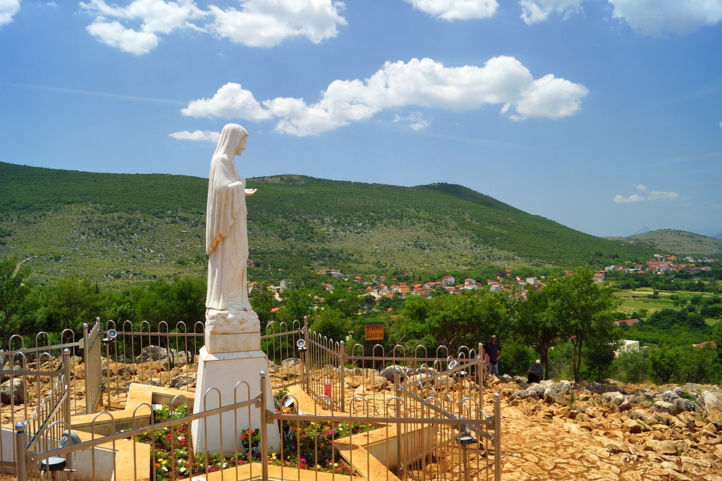
Međugorje, is a town located in the Herzegovina region of Bosnia and Herzegovina, around 25 km southwest of Mostar and close to the border of Croatia. The town is part of the municipality of Čitluk. Since 1981, it has become a popular site of Catholic pilgrimage due to reports of alleged apparitions of the Virgin Mary to six local children. 


The name Međugorje literally means "between mountains"

The messages attributed to Our Lady of Medjugorje have a strong following among Catholics worldwide. Medjugorje has become one of the most popular pilgrimage sites for Catholics in the world and has turned into Europe's third most important apparition site, where each year more than 1 million people visit. It has been estimated that 30 million pilgrims have come to Medjugorje since the reputed apparitions began in 1981. Many have reported visual phenomena including the sun spinning in the sky or changing color and figures such as hearts and crosses around the sun. Some visitors have suffered eye damage while seeking to experience such phenomena.

Mostar

Mostar is a city and municipality in southern Bosnia and Herzegovina. Inhabited by 113,169 people, it is the most important city in the Herzegovina region, its cultural capital, and the center of the Herzegovina-Neretva Canton of the Federation. Mostar is situated on the Neretva River and is the fifth-largest city in the country. 
The Old Bridge, built by the Ottomans in the 16th century, is one of Bosnia and Herzegovina's most recognizable landmarks, and is considered one of the most exemplary pieces of Islamic architecture in the Balkans.

Mostar is an important tourist destination in Bosnia and Herzegovina. Mostar's old town is an important tourist destination with the Stari Most being its most recognizable feature. Some noteworthy sites include Bishop’s Ordinariate building, the remains of an early Christian basilica, a hamam (Ottoman public bath), clock tower (sahat-kula), Synagogue (1889) and Jewish Memorial Cemetery, Nesuh-aga Vučjaković Mosque, Hadži-Kurt Mosque or Tabačica, Metropolitan's Palace (1908), Karagöz Bey Mosque (1557), Orthodox Church, Catholic Church and Franciscan Monastery, Ottoman Residences (16th–19th century), Crooked Bridge, Tara and Halebija Towers.

Kravice lakes
The Old Bridge was recently rebuilt and many of the edifices in the Old Town have been restored or rebuilt with the contribution of an international scientific committee established by UNESCO.

Koski Mehmed Pasina Dzamija (Koski Mehmed Pasha Mosque) - small but simply pretty Ottoman mosque built in 1618. Climb to the minaret to see a great view over the town. Entry: 3 KM, with minaret access: 5 KM.
Karadozbegova Dzamija (Karadjoz-Bey Mosque) - a modest Ottoman mosque built in 1557. Entry: 3 KM, with minaret access: 5 KM


Durmitor National Park

The Durmitor is a massif and the name of a national park in northwestern Montenegro. The highest peak, Bobotov Kuk, reaches a height of 2,522 meters.
The massif is limited by the Tara River Canyon on the north, the Piva River Canyon on the west, and by the Komarnica River Canyon on the south. To the east, the Durmitor opens to a 1,500 m (4,921 ft) high plateau, called Jezerska Površ (Plateau of Lakes). The Sinjavina mountain is located to the east of Jezerska Površ plateau.
The Durmitor mountain range is for the most part located in Žabljak municipality.

The Durmitor National Park, created in 1952, includes the massif of Durmitor, the canyons of Tara, Sušica and Draga rivers and the higher part of the canyon plateau Komarnica, covering the area of 390 km².
It was inscribed on the list of UNESCO World Heritage Sites in 1980.

80 kilometers long and 1,300 meters deep, the Tara River Canyon in the Durmitor National Park is the second largest in the world, after the Grand Canyon.

Durmitor National ParkThis breathtaking national park was formed by glaciers and is traversed by rivers and underground streams. Along the Tara river canyon, which has the deepest gorges in Europe, the dense pine forests are interspersed with clear lakes and harbour a wide range of endemic flora.


Region of Durmitor is the most important part of Dinara range of mountains characterized by high tops, abundant forests, deep gorges.There are 17 glacier Lakes in the Park as the highest top in Montenegro – Bobotov kuk.

Recreation has important place among activities at National Park Durmitor. Tracking, mountaineering, Alpine and Nordic skiing, rafting on Tara river, fishing, camping and visits by bus or car are ways of recreation that are done in the Park.

The lakes add significantly to the beauty of the Durmitor Mountain, and have been nicknamed Gorske Oči, or Mountain Eyes. They areCrno Lake, Veliko Škrčko Lake, Malo Škrčko Lake, Zeleni Vir, Jablan Lake, Valovito Lake, Vir u Lokvicama, Srablje Lake, Modro Lake, Suva Lokva Lake, Zminje Lake, Barno Lake, Pošćensko Lake, Zabojsko Lake, Vražje Lake, Riblje Lake, Zminčko Lake and Sušičko Lake.The most famous is the Black Lake covered with ice and crystals of frozen snowflakes in the winter. You can however swim in Black Lake in the middle of the summer.

Town of Zabljak is situated in the heart of Durmitor region, at the altitude of 1450 meters, what makes it the highest urban conglomerate in the Balkans. Zabljak is surrounded with 23 mountain peaks over 2200 meters and 18 majestic glacial lakes.


Bay of Kotor

The Bay of Kotor, known simply as Boka ("the Bay"), is a winding bay of the Adriatic Sea in southwestern Montenegro.

The bay has been inhabited since antiquity. Its well-preserved medieval towns of Kotor, Risan, Tivat, Perast, Prčanj and Herceg Novi, along with their natural surroundings, are major tourist attractions. Natural and Culturo-Historical Region of Kotor has been a World Heritage Site since 1979.

Its numerous Orthodox and Catholic churches and monasteries make it a major pilgrimage site.

It is surrounded by two massifs of the Dinaric Alps: the Orjen mountains to the west, and the Lovćen mountains to the east. The narrowest section of the bay, the 2300 m long Verige Strait, is only 340 m wide at its narrowest point.

   Towns
  • Herceg Novi — founded in 1382 and located in the entrance of the Bay of Kotor
  • Kotor — an ancient fortified town located deep down the Boka Kotorska bay, UNESCO World Heritage Site
  • Risan — the oldest settlement in the bay, historical capital of the Illyrian kingdom
  • Tivat — the youngest town in the Boka area established on the plateau at the bottom of Vrmac

     See
  • Kotor — visit its Old Town and the surrounding walls
  • Herceg Novi — take a walk on the 6km-long 5 Danica's esplanade to meet with the rich and diverse history of the town
  • Perast — a well preserved village, built entirely in barroque style, a UNESCO World Natural and Historical Heritage Site
  • Prčanj — small family-friendly place with great view of the Bay of Kotor
  • Tivat — a small town, quickly emerging into a major touristic, business and transport centre. Located in the vicinity of the Tivat International Airport, in summer 2014 it became home of a luxury yacht marina called Porto Montenegro

Pedestrian promenade Pet Danica

Named after five young women, all called Danica, who died during WWII, this pedestrian promenade stretches along the waterfront for over 5km from Igalo to Meljine. It's lined with summer bars, shops, concrete swimming platforms and the odd rocky cove, and in places it ducks in and out of tunnels carved through headlands. This was once the route of a trainline linking Zelenika to Sarajevo via Herceg Novi and Dubrovnik. The old stone railway station still stands at the foot of the Old Town, although it's long since been converted into a cafe.


Porto Montenegro

Single-handedly responsible for Tivat's transformation, this surreal town-within-a-town occupies 24 hectares which once were the historic Arsenal shipyard and naval base. It has five upmarket apartment buildings, a 'lifestyle village' of fancy shops, bars, restaurants and leisure facilities, a museum, and berths for 250 yachts. A Regent Hotel was set to open in May 2014, and eventually 630 luxury yachts will be able to dock here, including 130 superyachts.

The Porto complex is open to the public and it's a pleasant place to stroll and oggle oppulent yachts – if you're not prone to fits of rage at the injustices of contemporary economics. Kids will love the playground shaped like a pirate ship near the main entrance.
The success of such of a venture relies partially on enticing yacht crews to dock here for the winter, so bars, restaurants and activity providers operate year-round (unlike most of the Montenegrin coast). Prices are generally geared more towards crew-members than oligarchs and, while expensive for Montenegro, are reasonable by European standards.


Plitvice Lakes


The Plitvice Lakes National Park, Croatia’s most popular tourist attraction, was granted UNESCO World Heritage status in 1979. Located roughly halfway between capital city Zagreb and Zadar on the coast, the lakes are a definite must-see in Croatia.The beauty of the National Park lies in its sixteen lakes, inter-connected by a series of waterfalls, and set in deep woodland populated by deer, bears, wolves, boars and rare bird species. The National Park covers a total area of 300 square kilometres, whilst the lakes join together over a distance of eight kilometres.

There’s also quite an altitude difference – the highest point is at 1,280m, the lowest at 380m – although the total height difference between the lakes themselves is only 135m. (Veliki Slap, the largest waterfall, is 70m tall.)

The Park is open daily all year round, with longer opening hours during summer (usually 7am to 8pm). There’s an entrance fee which acts as a contribution to the Park’s upkeep and protection: for adults it’s 55 Kuna (£5.50/€7.25/$8.50) January to March and in November and December; 110 Kuna (£11/€14.50/$16.50) during April to June and in September and October; and 180 Kuna (£18/€24/$27) in July and August.
There are two entrances to the Park – excitingly titled Entrance 1 for the lower lakes and Entrance 2 for the higher lakes. Entrance 2 (and therefore some of the park) is normally closed in winter (November to April).

Plitvice Lakes isn’t just for summer. It’s a stunning place to visit any time of year as the different seasons see the Park take on different hues, whether that’s lush greenery in spring/summer, rich colours in autumn, or magical scenes in the snow and ice in winter.

There’s of course stunning scenery almost everywhere you turn in the Park – but for amongst the best photo opportunities (looking down on the lakes and waterfalls from up high – as seen below) it’s entrance 1 that you want to head to.
From Entrance 2 you can choose to start your exploration either by taking an electric boat across the largest lake in the park, or the ‘panoramic train’ (i.e. a shuttle bus) up to higher points in the park. You can also of course take the train back down to the entrance.

Dubrovnik


Banje Beach
Dubrovnik is a Croatian city on the Adriatic Sea, in the region of Dalmatia. It is one of the most prominent tourist destinations in the Mediterranean Sea, a seaport and the centre of Dubrovnik-Neretva County.In 1979, the city of Dubrovnik joined the UNESCO list of World Heritage Sites. The city boasts of many old buildings, such as the Arboretum Trsteno, the oldest arboretum in the world, dating back to before 1492. Also, the third oldest European pharmacy is located in the city, which dates back to 1317 (and is the only one still in operation today). It is located at Little Brothers monastery in Dubrovnik. In the bay of Dubrovnik is the 72-hectare wooded island of Lokrum, where according to legend, Richard the Lionheart was cast ashore after being shipwrecked in 1192. The island includes a fortress, botanical garden, monastery and naturist beach.


Among the many tourist destinations are a few beaches. Banje, Dubrovnik's main public beach, is home to the Eastwest Beach Club. There is also Copacabana Beach, a stony beach on the Lapad peninsula, named after the popular beach in Rio de Janeiro.

Dubrovnik's most beloved church is St Blaise's church, built in the 18th century in honour of Dubrovnik's patron saint. Dubrovnik's Baroque Cathedral was built in the 18th century and houses an impressive Treasury with relics of Saint Blaise. The city's Dominican Monastery resembles a fortress on the outside but the interior contains an art museum and a Gothic-Romanesque church.


No visit to Dubrovnik would be complete without a walk around the spectacular city walls, the finest in the world and the city's main claim to fame. From the top, the view over the old town and the shimmering Adriatic is sublime. You can get a good handle on the extent of the shelling damage in the 1990s by gazing over the rooftops: those sporting bright new terracotta suffered damage and had to be replaced.

Meet ex Yugoslavia - 6 beautiful and charming countries

Flag of the Yugoslavia

Yugoslavia was a country in Southeast Europe during most of the 20th century. It came into existence after World Ward I in 1918 under the name of the Kingdom of Serbs, Croats and Slovenes by the merger of the provisional State of Slovenes, Croats and Serbs with the formerly independent Kingdom of Serbia.


The constituent six socialist republics that made up the country were the SR Bosnia and Herzegovina,  SR Croatia, SR Macedonia, SR Montenegro, SR Slovenia, and SR Serbia.

In this blog, I will write about 10 tourist attractions in 6 ex - Yu countries. There are: Lakes Bled and Bohinj (Slovenia), Plitvice Lakes and Dubrovnik (Croatia), Bay of Kotor and Durmitor National Park (Montenegro), Međugorje and Mostar ( Bosnia and Herzegovina), Belgrade, Novi Sad and Đerdap George (Serbia). All these places are natural and anthropogenic and worth visiting. They attract tourist from all world. Lets start with Slovenia!

Bled & Bohinj

It is no over statement to rank Lake Bled & Bohinj amongst the most beautiful Lakes in the Alps. Lake Bled is a world famous destination, named by Yahoo Travel as one of the World's 10 Most Beautiful Lakes and not without good reason – surrounded by mountains and with a fairytale castle perched on a crag overlooking a 17th century church on an island, it is an outstandingly beautiful place. The town at one end is fairly developed with lots of bars, restaurants, hotels and other tourist facilities, whilst at the other end it is quieter and generally less built up. Taking a “Pletna” boat out to the island is certainly one of the highlights of any trip to Slovenia. Bohinj; less than half an hour’s drive west from Bled is located in the Triglav National Park and has an altogether more remote and tranquil feel – the serene lake, surrounded by beautiful mountains and quiet villages is a superb place to rest and unwind and is bursting with opportunities for outdoor activities from walking, mountain biking and boating / swimming in the lake in summer to skiing in winter. The popular ski resort of Vogel is perched on a mountain overlooking Lake Bohinj. Bohinjska Bistrica is an attractive town which also features the excellent Bohinj Water Park. Bohinj is also a popular starting point for treks up to Slovenia’s highest mountain Triglav, past 7 smaller high altitude lakes. Other attractions of the Lakes area include the charming medieval town of Radovljica10km south of Bled, the lovely Vintgar Gorge, numerous waterfalls, the Sava Bohinjka River running down from Lake Bohinj which offers scope for fly-fishing, kayaking and swimming. Overall the Lakes region is a wonderful area to enjoy Slovenia’s great outdoors all year round and a great place for a holiday.
Bled, already famous at the beginning of the 20th century as the most beautiful health spa of the then Austrian empire, attracted the European aristocratic elite. After WWII, one of the most attractive state residences of the former regime was located in Bled. Many of the world’s most important people thus enjoyed the beauties of Bled.

Map of Slovenia with Bled and Bohinj